04/12/2012 to 04/26/2012
This trip we decided we would try to see some friends and family we have not visited for a few years and then loop up through uncharted territory in Michigan. Lucky for us everyone we wanted to see was crazy enough to agree, so we had a great time.
First stop was Alabama, then into Georgia, up to South Carolina, and then Virginia - the Southeast section of our loop.
From there we headed to Michigan. First stop was Sleeping Bear Dunes on the west coast of the Lower Peninsula where we were so lucky to have freezing temps and gale force winds. Then across the Mackinac Bridge - creeping along at 40mph under threats of bridge closure, to the Munising area for Pictured Rock, waterfalls and more freezing temps and blustery winds
- Little River Canyon Preserve - AL
- Pigeon Mountain - Georgia
- Rock City - Lookout Mountain, GA
- South Carolina - Keowee Key & Greenville
- Petersburg Battlefield - Petersburg, VA
- Sleeping Bear Dunes Natl. Seashore, MI
- Sleeping Bear Dunes Hike
- Pictured Rocks Waterfalls
- Pictured Rocks National Lakeshore - MI
- Minnesota - Last Stop
After we left our friends in Athens, Alabama we were tooling along on our way to Georgia and we saw a sign for this national preserve, so naturally we had to make a quick stop.
We did not have time to do any of the hikes, but we did get a few shots of the waterfall and the park has been added to our list of places to see on our next trip through this area.

Little River Falls

Funny how you always have to tell people not to be stupid


It was a short stop, but worth the time
While visiting my sister and her husband we did a little hike on the Pocket Trail on Pigeon Mountain. Beautiful area. Lots of lush green but the wildflowers were already gone. Darn.


At the end of the trail is are the falls

The green growth in the stream made for some interesting running water shots

Standing at the base of the falls. Gives a good perspective of size

Quite lush

More falls

I have no idea what kind of spider this is, but he was rather lovely
Diane took us to Rock City, a place George and I have not been to in ages.
You have to admire the mind that conceived of this place. A great mix of schlock and incredible scenery.
Since my last visit was just after the earth cooled, I did not remember much and was chortling at the plethora of gnomes.

Entering Rock City

There are lots of gnomes living in Rock City


These are white Fallow Deer. Fallow Deer have been at Rock City for a very long time


Inside Fairyland Caverns - gnomes are everywhere, as are all the famouse characters from Fairy tales.

Not sure why it is Goblin Underpass

All schlock aside, the park is really a lovely botanical area

Mushroom Rock

A beautiful rock bridge

Shooting through the bridge arch

You can cross via this swinging bridge, which some idiot was bouncing on for fun

The swinging bridge from below

That is Lovers Leap and the waterfall

The famous 7 States Viewing area. Funny, all the states look alike from here.

Looking out from the viewing area

There we are, standing in front of Tenn, VA, KY, AL, GA and SC

More beautiful garden areas

This is Rainbow Hall. It is lined with colored lights and takes you to a diorama of all your favorite fairy tales

So, now you understand why it is Rainbow Hall
After leaving Diane & Steve we continued on our Southeast visiting with a stop at our friends in South Carolina. Paula & Bruce are always great hosts, taking us to some unique and fun places.
This trip we were introduced to Cherokee Trail Trees - one of which is in their neighborhood, and Falls Park on the Reedy in Greenville. Boy, has this place changed in the past few decades.

This is a Cherokee Trail Tree - yes it was bent that way as a directional sign

A little sign about the trees

Bruce is standing there for scale on the treee

Downtown Greenville and Falls Park

Paula & I at the beginning of the bridge walkway. That sign behind us talks about the old Mill that was here

There is a long, winding bridge over the Reedy River

Looking out from the bridge

It is a very vibrant area now, and it all started with a local garden club


It is a great place for families to gather and also to just stroll

This is a favorite photo spot

Naturally we had to get Paula & Bruce in as well

Gotta love a town with a Cofee Street

We loved this statue - a drooling wild boar
Another battlefield, but this one has a crater!
For years and years we have read stories about this battle and the crater that became a pit of slaughter.
Like most battlefields, what we imagined and what the place actually looks like are vastly different. For one thing, the crater is no where near as huge as I had always imagined it.
We only had time to do the Eastern Front on this trip. Hopefully we will soon finish the Western Front and Five Forks.

Confederate Battery 5

The Dictator - a 13 inch motor.


The powder magazine next to the Dictator

Confederate Battery 8 - or a recreation of it. The original was captured by black troops

As you can see, the Park Service did a good job recreating this defensive post


Pits, pointed stakes, guns.

This is a recreation of a soldiers hut. 4 men would occupy this during the winter. Cozy

The tall grass denotes where Ft. Morton stood. Gen. Burnside watched the Battle of the Crater from here.

What is left of the Taylor Plantation slave quarters at Ft. Morton

Going to the Crater

Recreation of the mine entrance

And they call it a mine! OK channeling Gimli.

Walking around the crater
We stayed in Glen Arbor, MI., a quaint little town just outside the Park. All the locals kept telling us we had to go to the dunes and watch the sunset, so we headed out to catch the last rays.
Now, the weather is raw, windy and really cold so it took a lot of fortitude to stick it out and wait for the sun to set.
Then there were the bugs - thousands of them swarming around.
But we were good little tourists and got some really nice shots.


Naturally we had to stop and take pictures of this covered bridge. We are succers for covered bridges

One of the boardwalks for looking up and down the coast

Bugs, tons and tons of bugs

Yes, my personal terrorist. Actually the bugs were so bad George had to cover up

Shot of the surrounding dune area

Looking up the lake shore

I am actually freezing here - Popsicle Sharon

Ah, yes. The Shadow People were there as well. Seem to run into them a lot

Beautiful shot of sun on water
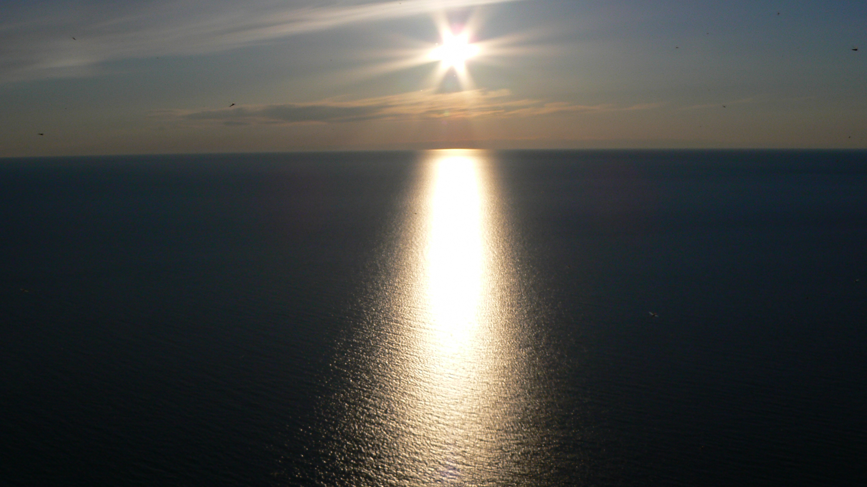

The sun is finally setting

I kept thinking of the movie Endless Summer - exactly the same except we were not surfing and it was freezing


Yes, it was worth all the cold, wind and bugs to see this
It is still cold and windy but we figured we would do at least one hike at Sleeping Bear Dunes.
Now, this would be a really lovely, refreshing trek in better weather but today it is more of another endurance adventure.
But what the heck, we are here and being tourists we have left our common sense behind.

First, climb up to the Plateau. Not bad yet because some of the wind is blocked

Lots of sand and sun. And 30mph wind gusts

Walking through a ghost forest. This is where the sand has overwhelmed trees and they have died.


Brisk stroll along the shore
So the 3 layers of clothing and bandana around my ears did help, but I am still freezing
We left Glen Arbor and headed to the Upper Peninsula and the area around Munising and Grand Marais. We love waterfalls, so this area was a treat. All of these falls are part of the Pictured Rocks National Lakeshore.

Miners Falls Sign

Approaching Miners Falls

Miners Falls

This was a fast running fall

Munising Falls


Wagner Falls - almost missed this one. The very small parking area is right on the road

The state has done a good job erecting boardwalks to their falls


Au Train Falls - this is part of the Autrain Hydro system


Canyon Falls was the best of all

The little hike in was through some amazing trees

We loved this old tree and the roots that grew around the large rock

The quiet of the stream is deceptive

The falls - they were really flowing

The speed is hard to gauge from the photo

Standing overlooking the rushing water

More falls shots


Some wonderful rocks lined the gorge

Today we visited Pictured Rocks - the first National Lakeshore. The sandstone here is over 500-million years old, and the "picture" is the mineral staining.
Wish the weather had warmed up a bit so we could have enjoyed some of the hikes and light houses, but the temps are still chilly and the wind is more than brisk.

Yes, this is the most photographed spot in Pictured Rocks


Miners Castle

Miners Beach. Needless to say Lake Superior is very, very cold

Looking along the coastline

More coastline

More sandstone
Last stop on our trip was Minnesota.
One of the tourist things we did was the Foshay Tower. Built in 1929 by Wilbur Foshay, it has been restored to its former Art Deco style and is now a hotel.
We strolled around the observation deck and had some great views of Minneapolis.


The Foshay Tower

The observation deck. Some great views of the Minneapolis area

US Bank Tower and American Express

I think this is the Wells Fargo building


